
What an Agentic GIS System Looks Like in Practice
In the previous article, we explored why GIS is moving beyond traditional automation. But what does an agentic GIS system actually look like when applied to a real problem?
Let’s ground the idea.
A Typical GIS Workflow
Consider a common analysis, such as assessing access to healthcare services.
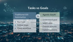
A traditional workflow usually involves selecting a study area, loading service locations, running a distance or network analysis, and producing a map.
This works until something changes.
What if the analysis radius needs adjusting?
What if the dataset is incomplete?
What if the question shifts from distance to accessibility?
At that point, scripts need rewriting and models need reconfiguring.
Starting with a Goal, Not a Tool
An agentic GIS system starts from a different place.
Instead of predefined steps, it begins with a goal:
“Assess healthcare accessibility for this area.”
From there, the system identifies relevant spatial layers, selects suitable analysis methods, validates available data, flags gaps or uncertainty, and explains results in plain language.
The output is no longer just a map. It is context, reasoning, and evidence.
Why This Matters in Real Projects
Analysis is rarely static in real-world environments like local councils, infrastructure teams, emergency planners.
Questions evolve. Data changes. Time is limited.
An agentic approach reduces manual rework, surfaces assumptions early, supports clearer discussions with stakeholders, and scales beyond one-off analysis.
Instead of repeatedly rebuilding workflows, teams focus on interpreting results.
The Role of the Human Expert
Crucially, the agent does not replace expertise.
It does not decide where to build, evacuate, or invest. It prepares information so humans can make informed decisions.
This distinction matters. It keeps responsibility where it belongs and builds trust in the system.
Looking Ahead
Agentic GIS systems are not about complexity for its own sake.
They are about aligning spatial analysis, system design, and real decision-making needs.
In the next article, we’ll explore how these systems are structured — from simple agents to production-ready architectures.